niponica is a web magazine that introduces modern Japan to people all over the world.
2017 No.22


Tokyo, a 400-Year Narrative

Tokyo’s Roots Go Back 400 Years
High buildings pressing closely together, transportation routes spreading like a spider’s web, green spaces scattered about the city core... Much of this picture has its roots in the old city of Edo, which has become present-day Tokyo.
From a conversation with Okamoto Satoshi
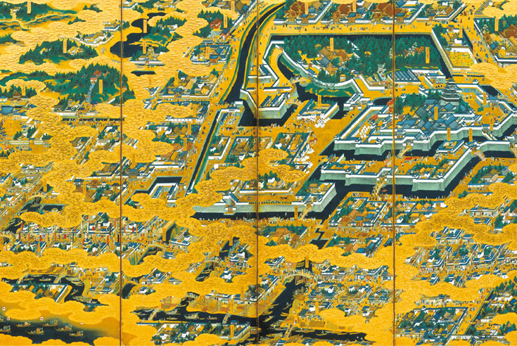
Edo Castle and urban environs in the early Edo period (17th century). The inner moat has already been made to zigzag around the castle, and residential districts for daimyo feudal lords have been laid out nearby. The Nihonbashi district is seen in the foreground. The bridges over the waterways are thronged with people, demonstrating the energy and dynamism of the metropolis. (This 17th century “Edo-zu Byobu” folding screen is the property of the National Museum of Japanese History.)

Tokugawa Ieyasu (1542-1616), who established the Edo government in 1603, marched into Edo in 1590. Edo was about 500 kilometers east of Kyoto, which was the capital at that time. Edo was quite rural, with large mixed forests and waterlands. He quickly began making major improvements to Edo Castle and laying out the city. First, he had water channels cut so that boats could crisscross the area. The old castle area, where the Imperial Palace locates now, was at the inner end of an estuary, and he had it filled in. Today, the Marunouchi area between the Imperial Palace and Tokyo Station, and the Hibiya district just south of the palace, are packed with office buildings, but they were once part of the saltwater bay. After the estuary was filled in, nearby hills were cut to make a new watercourse for the Kanda River, guiding it to the Sumida River.
After all this tremendous work, a moat was constructed to surround the castle. This was the inner moat. Around it, the outer moat, 12 kilometers long, was developed as a major line of defense against enemy attack.
The water channels were also used to promote urban expansion. Back then, 300 feudal lords (daimyo) were posted temporarily to Edo from different parts of the country. These were just some of the many who swore allegiance to the government of the Tokugawa shoguns (military leaders in Japan until the middle of 19th century). The government assigned them homes in large areas along the watercourses and streets. The daimyo districts are said to have taken up 70% of the urban land. As more became established around the water channels, the city became larger and larger.

A scene today within the grounds of the Imperial Palace. The Nijubashi Bridge crosses the inner moat.
Photo: Takahashi Munemasa
In 1654, the newly constructed Tamagawa Aqueduct began drawing water from higher ground in the west. Some of the water flowed to the outer moat, and from there to the inner moat, then to the Kanda River, the Nihonbashi River, and finally to the sea. The audacious urban plan was now complete. Conceived by Ieyasu 50 years earlier, it had spanned more than a generation. Edo thrived as a “city of water,” and would eventually grow to become a metropolis of one million people.
Edo ended up serving as the nation’s primary castle city for almost 300 years. Why was Edo able to take the place of Kyoto, which had been the capital for many centuries? There are a number of reasons, one of them being that the region’s terrain offers great potential. Recognizing this fact, Ieyasu developed his grand plan to transform Edo into a “city of water.” Today, we can only be astounded by his bold concept, impossible to conceive of today, and the tremendous energy of the people who transformed his concept into reality.
If you compare a map showing the city in the 17th century with a map of modern-day Tokyo, you will see that Tokyo’s layout is built on top of the old Edo layout. Expressways were constructed above the water channels, which were filled in. Sections of railway and subway lines follow the castle’s outer moat. The wide swaths of land once occupied by daimyo residences are now used for other purposes, such as government buildings, schools and parks. Meiji Jingu Shrine and the Shinjuku Gyoen National Garden were also daimyo residential lands at one time. Many of the high buildings crowding the city center were built on land where daimyo residences once stood. Ambitious urban developments, such as those of the Marunouchi and Roppongi districts, also trace their roots back to those times.
What was once an undeveloped settlement on the seashore was transformed over a period of 400 years into one of the world’s largest metropolises. The groundwork for it all was the city of Edo, based on Tokugawa Ieyasu’s vision. Stroll around Tokyo today, and you can still find traces of Edo history in many places.
1590 Map


Above left: Topography of the city of Edo around the year 1590, when Tokugawa Ieyasu took possession of the castle. At the time, the shallow waters of the long inlet came almost as far as the castle. Edo-maejima extends down the middle of the map, and the area in the vicinity of Edo-maejima’s tip is now the Ginza district.
Above right: The same area in Edo, but around 1636. Land is being reclaimed by filling in the estuary. The inner and outer moats are almost finished, and the Kanda River has been rerouted to a course close to its present channel. (Cartography: Oguro Kenji)
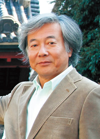
Okamoto Satoshi
Born in Tokyo in 1952. Graduated from the Department of Architecture, Faculty of Engineering, Hosei University, Tokyo. Doctor of Engineering, and president of the Okamoto Satoshi Urban Architecture Research Institute. Field of expertise: urban morphology. For more than 40 years, has studied and researched the history of Tokyo’s development, pursuing the subject from different angles.