NIPPONIA No. 37 June 15, 2006
A Flight over History and Culture

Old reservoir canals on the Saga Plain
Above left: The Saga Plain has the greatest expanse of rice fields on the island of Kyushu. The plain faces the Ariake Sea, where the difference between high and low tides is quite pronounced. This makes irrigating and draining the rice fields a challenging job, but farmers cleverly solved the problem long ago with reservoirs. The meandering reservoirs are still used today. In the old days, the reservoirs were important in other ways as well, providing water for household purposes and offering a habitat for sources of food like carp and a plant called water caltrop.
(Photo: Watanabe Manabu)
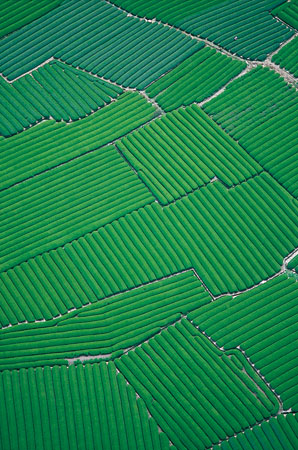
Makinohara-daichi tea fields
Above right: From this height the ridges and grooves look like green velvet, but they are actually row upon row of tea bushes. We are above Makinohara, a fairly flat upland measuring 25 km north to south along the lower reaches of the Oi River in Shizuoka Prefecture. The land here developed long ago as a fan-shaped alluvial delta, and was later thrust upward by geological forces. This makes for good drainage and excellent conditions for tea cultivation. Plantations were developed here beginning in 1869, very soon after the Meiji Restoration, and today the area accounts for about 40% of the tea production of Shizuoka Prefecture, Japan's most important prefecture for the tea industry.
(Photo: Toyotaka Ryuzo)
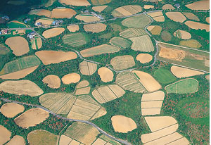
Fields as circles on the island of Fukue
Above left: The Goto Islands to the west of Nagasaki come in different sizes, and there are about 140 in all. The biggest one, Fukue, was born from volcanic activity and has fairly gentle slopes. Seen from the air, these strange shapes on Mount Kyonodake could be part of an abstract painting, but they are actually roundish fields called maru-bata, cultivated since the 17th century for crops such as sweet potatoes, rice and barley. Camellias have been planted in spaces between the fields to act as a windbreak.
(Photo: Watanabe Manabu)
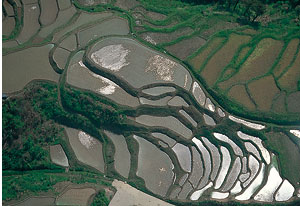
"Thousand rice fields" of Wajima
Above right: Japan has little flat land so some highland slopes were carved into terraced fields. When the rice fields are so numerous you cannot count them, they get the nickname, senmai-da ("1,000 paddies"). The photo shows the "1,000 paddies" of the Shiroyone district in Wajima, Ishikawa Prefecture. Actually, there are more than 2,000 of them, looking like scales on a fish, on slopes with a total area of just 1.2 hectares. The terraces continue right down to the coast. At night, each one shimmers when there is a moon. The scene, called ta-goto no tsuki ("moonlight in each paddy"), has long inspired haiku poets.
(Photo: Toyotaka Ryuzo)