NIPPONIA No. 37 June 15, 2006
Topography, Climate and Culture
Written by Masai Yasuo, honorary professor of geography and cartography, Rissho University
Photos by Watanabe Manabu
A Country of Islands
In Japan, we sometimes call our country Nihon retto ("the Japanese archipelago"). Our long, thin string of islands lies off the eastern shore of the largest continental landmass, Eurasia, making Japan one of the easiest countries to locate on a world map. The islands are separated from the continent by the Sea of Japan, the East China Sea and the Sea of Okhotsk, and on the other side, to the east and south, is the world's biggest ocean, the Pacific.
The four main islands form an arc about 2,300 km long, from Hokkaido in the northeast to Honshu, Shikoku and Kyushu toward the southwest. The Nansei Islands continue on for another 1,000 km or so: the biggest of these is Okinawa. The Izu Islands and the Ogasawara Islands stretch out into the Pacific south from central Honshu for about 1,000 km. The most southern islands are a few degrees below the Tropic of Cancer.
So the country is all islands! Even the largest one, Honshu, has few places more than 100 km from the sea. Japan is one of the world's most rugged countries, with mountains and hills making up more than 80% of the landmass. Even Mount Fuji, the highest peak at 3,776 meters, is close to the coast. Because there are mountains almost everywhere, they occupy a fond place in the Japanese psyche, and school songs throughout the country tend to identify the local area with mountains.
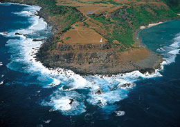
Yonaguni-jima is the westernmost island in the Japanese archipelago. On a clear day, you can see the island of Taiwan to the west from here. The photo shows San'ninudai, a small tableland beside a steep cliff 40 meters high, on the eastern side of the island.
From Ice Floes to Coral Reefs
Over millions of years, the Pacific, Philippine and Nankai Micro tectonic plates on the crustal floor of the Pacific Ocean have been sliding from the east and south under the North American and Amur plates that form the continental crust. This has created a long, thin line of mountains. The lower mountains lie under the sea, and the higher ones are the Japanese archipelago. This explains why Japan has no large plains. In many places, mountains push against the seacoast. Earthquakes, hot springs and volcanoes are common. Mounts Fuji, Aso and Asama are just three of the more than 60 active volcanoes. We can still see the results of the glaciers that shaped the terrain in Hokkaido and in central Honshu's Japanese Alps until about 10,000 years ago.
The climate and the four distinct seasons are greatly influenced by the mountains and surrounding seas. Humidity is generally high because of the warm ocean currents around much of the country. Winds pick up moisture as they cross the water, and when they hit the mountains they drop that moisture as rain or snow. Swollen rivers cascade over waterfalls and continue to erode innumerable valleys. There is no desert, and forests cover much of the land. Spring is known for cherry blossoms, early summer for green rice fields. Heavy rains come in early summer when the tsuyu front passes by, and in late summer and autumn when typhoons hit. Summer is a time to visit the mountains and the sea. And then there are the fall colors.
Winter brings cold, dry winds from the continent, sweeping across the Sea of Japan's warm current to pick up plenty of moisture and drop it as snow as the air rises over the archipelago's mountains. On the Sea of Japan side of central Honshu, small highland plains surrounded by mountain ranges 2,000 to 3,000 meters high get snow accumulations of 1 to 3 meters and up, more than almost anywhere else in the world. The winter festival in Sapporo, Hokkaido, attracts many tourists from Japan and abroad. In late winter, ice floes cover the Sea of Okhotsk to the Hokkaido coast, the southernmost place for ice floes in the world.
Meanwhile, palm trees thrive in Okinawa's sub-tropical climate. Okinawa also has superb coral reefs. Ice floes and coral reefs—Japan is quite the unusual country!