Tsunami Monitoring with Optical Fiber Network
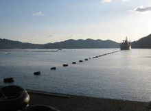
A work ship lays underwater cables to monitor earthquakes in real time.
©JAMSTEC
Following the Great East Japan Earthquake, tsunami caused serious damage. Tsunami is a series of waves caused by a sudden change in underwater landforms as a result of an earthquake. Tsunami caused by the Great East Japan Earthquake rose as high as 20 meters in some areas, much higher than expected. The experience of the March 11 disaster made the study on tsunami even more important.
Normally, scientists judge if tsunami will result from an earthquake or not by analyzing seismic waves reaching land. However, this analysis is not enough to get accurate information on tsunami.
Japan has already built a network of observation equipment, such as seismometers and tsunami recorders, installed on the seabed and connected to one another with optical fiber cables. However, the problem is that only 55 seismometers are installed on the seabed by the government and research organizations in 10 oceanic areas, while Japan has installed about 1,500 land-based seismometers. Now, a major project is in progress to increase the number of seabed seismometers by a significant margin.
Concerning the seabed off the Pacific coast of the Tohoku region hit by the Great East Japan Earthquake, a project began in the spring to install seismometers and tsunami recorders at more than 150 locations in addition to three seismometers already there. Optical cables connecting those meters will stretch about 5,100 km, a length equivalent to more than half the distance between Tokyo and Los Angeles.
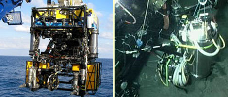
Left: Hyper Dolphin, a remotely operated vehicle (ROV), is used to lay Submersible cables and equipment as well as to repair them. An ROV is also used to explore marine resources on and under the seabed. ©JAMSTEC
Right: ROV Hyper Dolphin (left) installs a seismometer (right) on the seabed.
©JAMSTEC
In the Nankai Trough area, preparations are being made to install 25 more meters in addition to 20 already in place. In the deep sea, there are places where the ocean current causes special noises that can interfere with the accurate measurement of an earthquake. In the Nankai Trough, therefore, seismometers are buried in seabed holes drilled by a remotely operated vehicle (ROV), an unmanned machine controlled from aboard a ship. An ROV can also repair problems with observation equipment.
Data from seismometers are transmitted to the Japan Meteorological Agency for use to increase the accuracy of an emergency earthquake-warning system. The system informs cities and towns of an earthquake period, seismic intensity and the place where the earthquake originated. Data from tsunami recorders will give an important measure to accurately predict and know the size of tsunami and the time of their arrival on land, which we cannot know in real time now. These data will be useful in working out disaster prevention measures to protect people and property from tsunami.
Japan is determined to build a country strongly prepared against earthquake-caused disasters by accumulating data and making plans from the results of these challenging efforts.
(Updated in June 2012)