|
|
|||||||
|
|
|||||||
|
|||||||
| | Web Japan >> | Trends in Japan >> | Business & Economy >> | A Map For Publishing Success | |
|
A MAP FOR PUBLISHING SUCCESS Informative Maps Offer More Than Just Directions (December 1, 2005)
Packed with Facts Seibido was prompted to publish these maps by the terrorist attacks in the United States on September 11, 2001. Along with the subsequent decrease in international air traffic, sales of foreign travel guides fell dramatically, and Seibido felt a pressing need to make up for lost sales by introducing new publications. The company reasoned that a product combining an array of statistical, historical, and political information with a world map would appeal to the general reader's appetite for knowledge. Their plan was right on target, and the atlas has won over a wide readership of all ages. In autumn 2005, Seibido plans to release yet another atlas in the same series, this time focusing on the history of Japan's Showa era (1926-1989).
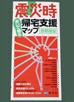
A work with a focus on more distant history is Take a Walk Through Edo and Tokyo, released in 2002 by the publishing firm Jinbunsha. The book features old maps of Edo (Tokyo's former name, in use until 1868) alongside corresponding maps of present-day Tokyo so the reader can easily compare the two. Sales of this volume have exceeded 80,000 copies, an exceptional figure for a publication of this type. Show Me the Way to Go Home Planning for this map and guidebook began after the October 2004 earthquake in Niigata Prefecture. Experts predict that if a powerful earthquake of comparable strength strikes the greater Tokyo area directly, as many as 6.5 million commuters will be unable to return to their homes, in effect becoming refugees. This map functions as a guide for people who find themselves in downtown Tokyo after a massive earthquake, without any means of transportation, and must walk back to their homes in suburban areas. The guide introduces readers to 12 different routes leading out to the suburbs from downtown based upon a list of roads designated for such use by the Tokyo Metropolitan Government. In order to provide the most detailed information possible, the book's editors walked the routes themselves and took note of narrow streets, overhead power cables, concrete block walls, and other potential dangers. From central Tokyo, the guide's focus extends about 22 km to the south, 36 km to the west, 32 km to the north, and 38 km to the east. On July 23, just under two weeks before the guide's originally slated release date of August 4, a relatively strong earthquake jolted Tokyo. Immediately afterwards, having received word from major book retailers about the potential for bulk sales to large companies in addition to a flood of orders from individuals, the publisher decided to move up the guide's release date and increase its initial print run from 60,000 to 110,000 copies. In mid-October, the same publisher released two new versions of the guide, one for Nagoya and the Tokai region and another for the Kyoto-Osaka-Kobe area. Confident in the guides' long-term appeal, they expect the series to sell a combined total of 1 million copies. The rash of successful new products in the map sector is a sign of how Japanese firms have reacted to a downturn in business by innovating to open up new markets. Copyright (c) 2005 Web Japan. Edited by Japan Echo Inc. based on domestic Japanese news sources. Articles presented here are offered for reference purposes and do not necessarily represent the policy or views of the Japanese Government. |
KEEPING TRACK (February 6, 2004) DRIVING THE INFORMATION HIGHWAY (May 2, 2003) |
|||||||||||||
|
||||||||||||||

 |
 |
 |