|
Horde of "Ice Monsters" Over-running the
Mountain Slopes
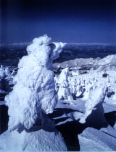
On the flanks of Mt. Zao, which straddles the border between Yamagata and Miyagi prefectures, coniferous trees such as the Aomori Fir cover the slopes at altitude between 1,300 and 1,600 meters (4,265 and 5,249 feet). When winter arrives, a seasonal wind starts blowing in from Siberia. As the air passes over the Sea of Japan it picks up moisture and, after crossing the Asahi Mountain Range that lies to the west of Mt. Zao, this moisture forms clouds of supercooled droplets. Pushed by strong winds, these clouds frost the conifers on the slopes of Mt. Zao with an icy crust. This process is repeated over and over again and the trees become completely enveloped in ice, taking on strange shapes that gradually resemble animals or the human form. These giant frosty mantles, the tall ones reaching heights of several dozen meters, are known as "ice monsters." Running across slopes blanketed with snow, the horde of "ice monsters" presents a sight unlike any other. They start appearing at around the end of January and the best time to see them is from the end of February to early March. Tourism is thriving stronger than ever around Mt. Zao, a volcanic scenery long known for its grandeur, as well as for the numerous hot springs surrounding it. Many skiers visit Mt. Zao to enjoy the splendid views out on the slopes, especially when the frost-covered trees appear. Photos: (Top) Trees covered with ice in Mt. Zao (Yamagata Tourism Association). Unauthorized reproduction of the
photos in this page is prohibited.
Related Links: |
|


